SOUTH GEORGIA AMATEUR RADIO
  • Home
  • Services
  • Repeaters
  • Contact
  • News & Updates

New First Coast DMR Repeater, Douglas

7/11/2021

1 Comment

 
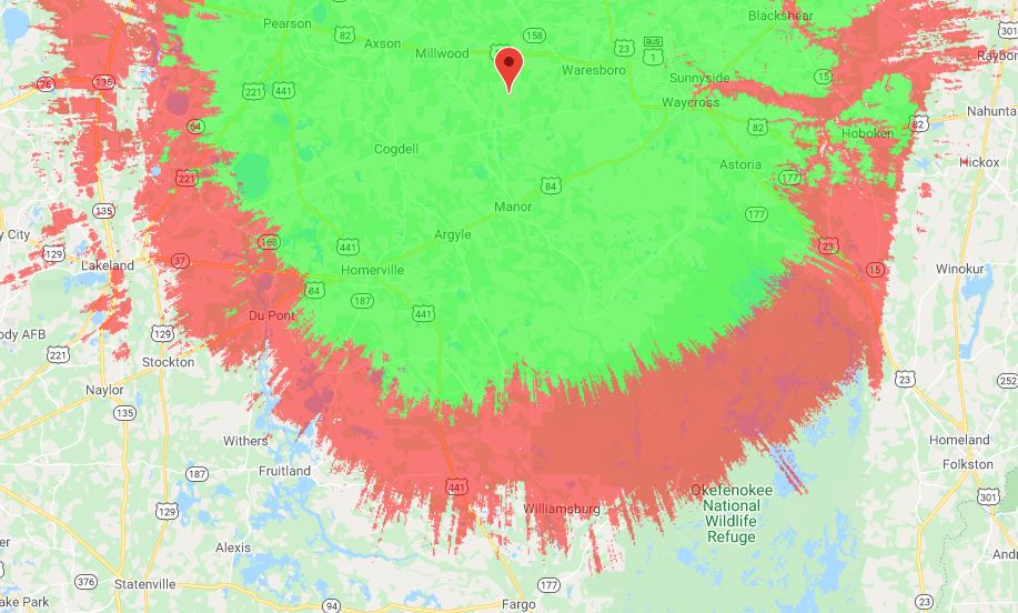
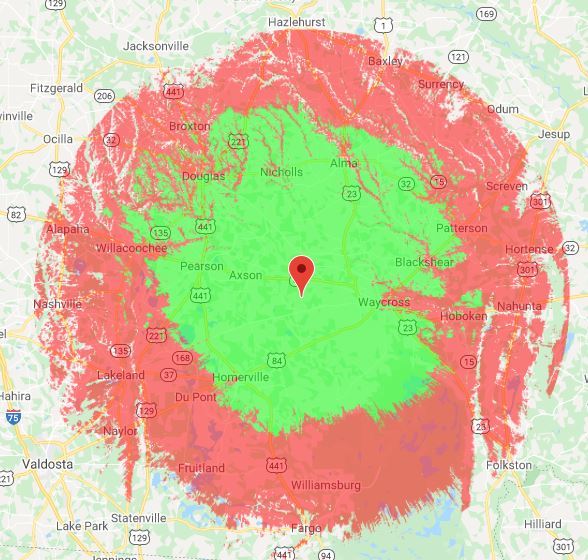
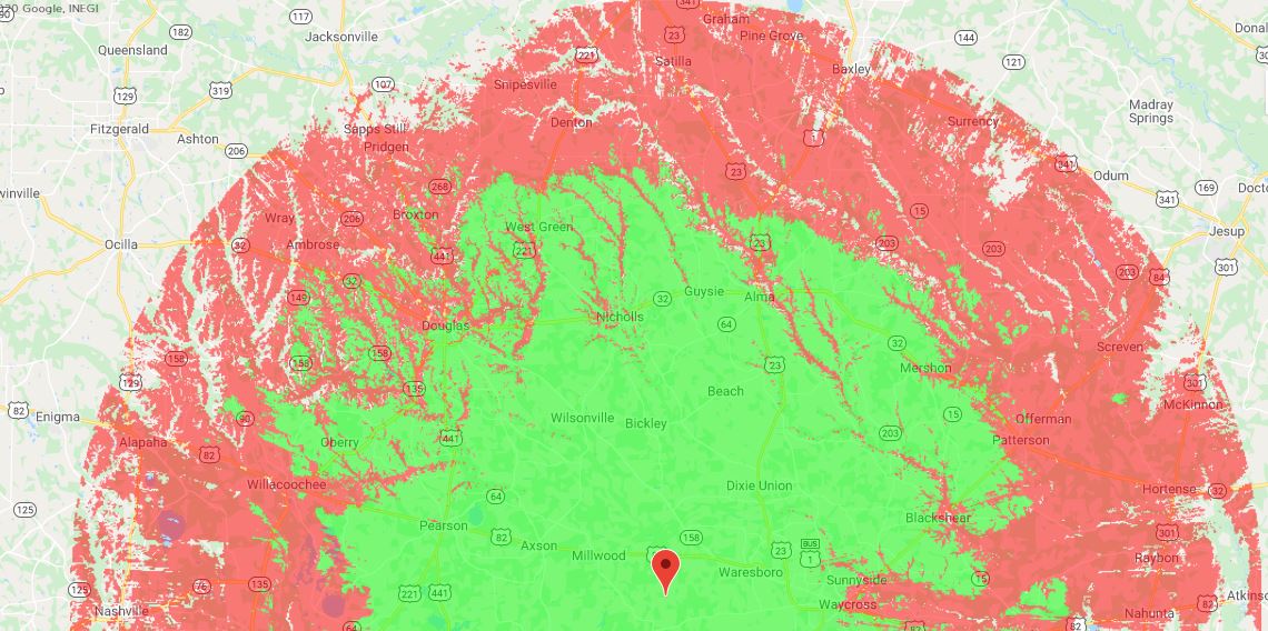
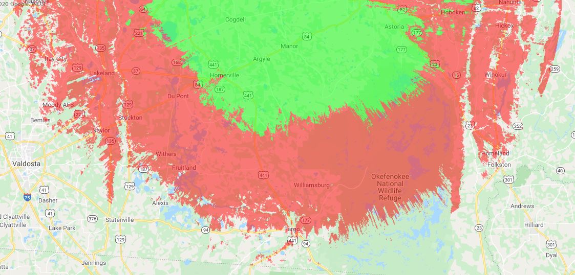
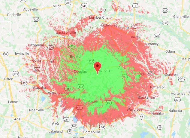
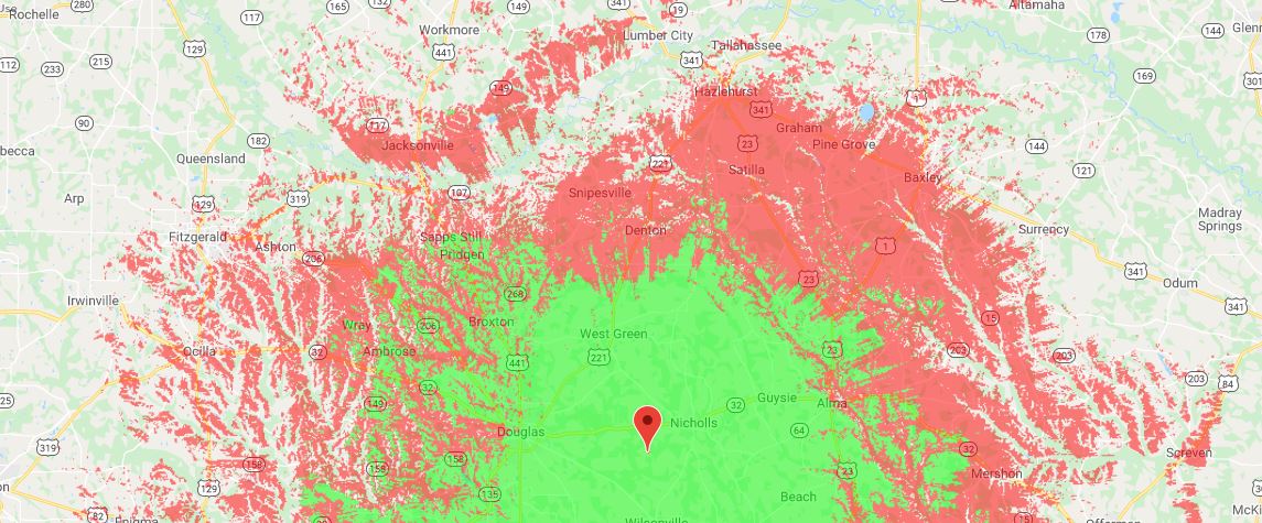
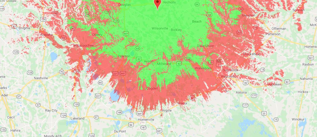
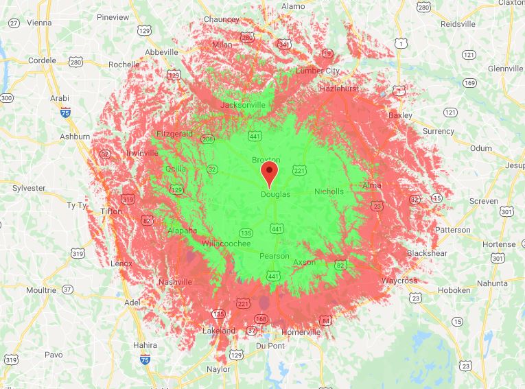
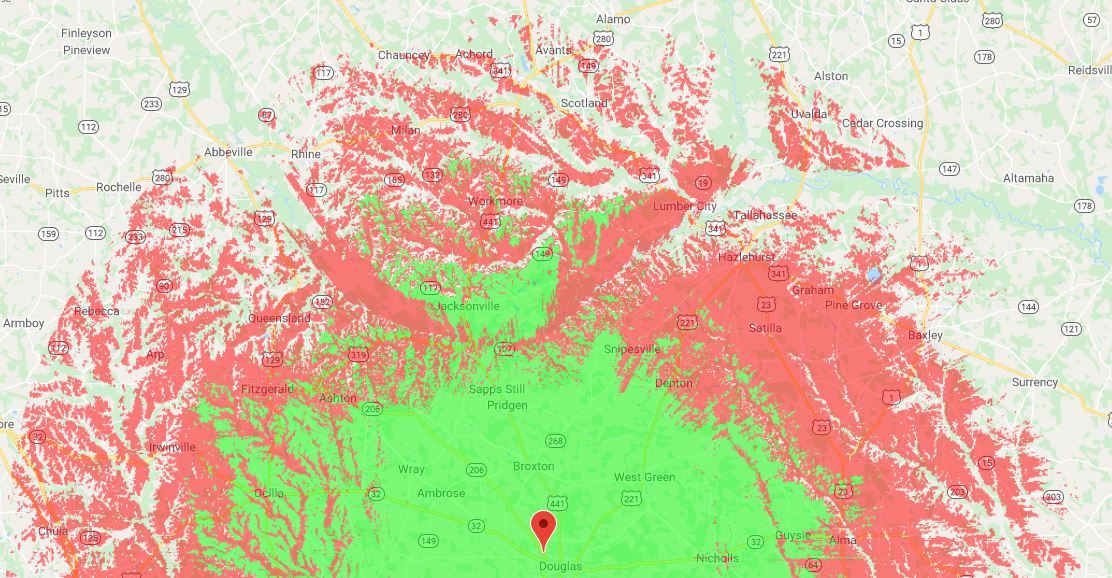
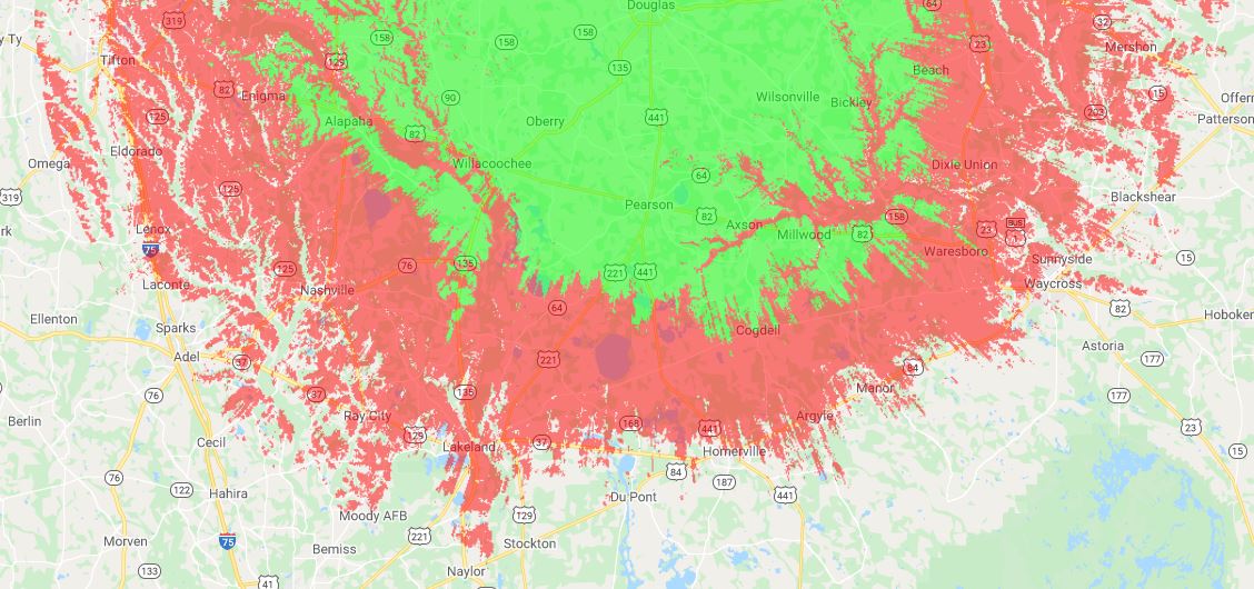
A new DMR repeater is on the air in Downtown Douglas, GA. The new repeater is apart of the First Coast DMR Group's set of linked repeaters across the state. For more info about this repeater or how you can help out, visit their website below:

http://firstcoastdmr.org/

Frequency info:

​443.1375 + CC 3

Picture
1 Comment

FTM-400XDR Extended Transmit Mod [Memory Fault]

7/11/2021

0 Comments

 
Picture
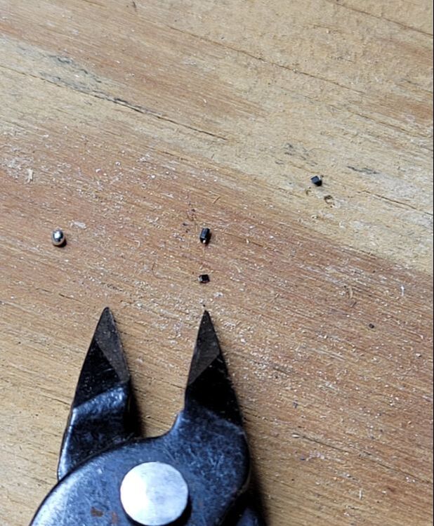
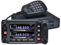
We recently modified a Yaesu FTM-400XDR transceiver for out-of-band transmit coverage. This will VOID your radio's warranty. This should not be done unless you're experienced with soldering extremely small components as well as having a license and permission to transmit on other parts of the band. Other instances may include GMRS, Public Works, Radio Remote Pickup, etc. ***Each of these services requires its own license and you must adhere to their own rules. Do this at your own risk***. We will not be showing you how to do this, only helping the Memory Error after completion. 

1. Copy your data from your radio to an SD Card under the settings menu. 

2. Read your data from an SD Card via RT Systems Software, then save to your PC.

3. Remove the appropriate diode
​*at your own risk

Picture

4. Power up your radio, format your SD Card (inside your radio via the front panel), then copy the current settings to the SD Card again. 

5. Insert the SD Card into your PC, then "Read from SD Card" in RT Systems Software. (You'll notice there are only 1 or 2 pre-written channels since your radio has been factory reset)

6. Copy and Paste your memory channels from the old config file to the new config file. Your old config file cannot be written to the radio after the modification, only the new config file you read from the radio can be edited and exported. 

7. Now copy that data to your FTM-400. Your radio should read this new format. 

0 Comments

2021 Patterson, GA Ham Radio Swap Meet and Tailgate

4/6/2021

0 Comments

 
Picture
http://www.tricountyares.com/2021-swap-meet/

2021 Swap Meet
14TH ANNUAL
PIERCE COUNTY ARES GROUP
HAM RADIO SWAP MEETSATURDAY, MAY 1ST, 2021 PATTERSON LION'S PARK
PATTERSON, GA.8:00AM-12:00PM

THE PATTERSON LION'S PARK IS
1 . 2 MILES EAST OF HIGHWAY 84 ON HIGHWAY 32THIS IS A TAILGATE SWAP MEET
OR
BRING YOUR OWN TABLE(S)

THE PRICE IS RIGHT - FREE

Directions:

>  FROM JESUP TAKE HIGHWAY 84 TO THE HIGHWAY 32 INTERSECTION (TRAFFIC LIGHT) AND TURN LEFT ONTO HIGHWAY 32 - GO 1. 2 MILES

>  FROM WAYCROSS TAKE HIGHWAY 84 AND TURN RIGHT AT HW 32 - GO 1. 2 MILES

>  FROM THE BRUNSWICK AREA TAKE HIGHWAY 32 STRAIGHT TO THE LION'S PARK ON YOU RIGHT  AS YOU ARE ENTERING PATTERSON - 2 . 2 MILES PAST THE CITY LIMIT SIGN

>  FROM ALMA COME STRAIGHT DOWN HIGHWAY 32 THROUGH THE INTERSECTION AT PATTERSON AND GO 1. 2 MILES

>  FROM JACKSONVILLE TAKE US1 TO HIGHWAY 301 IN FOLKSTON AND HIGHWAY 301 TO HIGHWAY 32 IN HORTENSE.  TURN LEFT AND GO APPROX 11 MILES TO PATTERSON CITY LIMIT SIGN.   2 . 2 MILES PAST THE CITY LIMIT SIGN TO LION'S PARK

RAFFLES AND REFRESHMENTS

LOOK FOR THE SIGNS AT THE PARK ENTRANCE

<<<<  PRIMARY TALK-IN FREQUENCY 145.270 (- 600) (141.3)  >>>>
<<<<  SECONDARY TALK-IN FREQUENCY 145.370 (- 600) (141.3)  >>>>

FOR MORE INFORMATION CONTACT Clay Wilson KI4LDC via ---  Email


0 Comments

Coverage Maps for KE4ZRT-UHF [443.000] Repeater, Millwood GA

10/7/2020

0 Comments

 
This is the coverage map for "The 443" machine which includes Analog and Yaesu System Fusion [C4FM]. The GREEN depicts coverage for Digital Fusion using a moderate mobile radio and antenna. The RED depicts coverage for Analog FM using the same radio and antenna. Again, base station and propagation anomalies may differ. 
Picture
Picture
Picture
0 Comments

Coverage Maps for KE4ZRT-VHF [147.045] Repeater, Millwood GA

10/7/2020

1 Comment

 
The coverage for "The 045" are a little larger due to the antenna's height above the average terrain (HAAT). The software has a km/mile limit, so some of the edges are rounded off. Again, these coverage maps are purely based on setup, configuration, and propagation. YMMV! GREEN depicts low power mobiles and handheld devices, while RED depicts coverage for mobiles with high-gain antennas and base stations with antennas >10ft above ground. 
Picture
Picture
Picture
1 Comment

Coverage Maps for the KM4EYX APRS Digipeater and iGate

10/7/2020

0 Comments

 
The Digi/iGate on 144.390 has a much larger footprint if you're operating via base station or through another Digipeater. The RED depicts >50w nodes with 1/4 wave antenna >10ft off the ground. The GREEN depicts 5-50w nodes (mainly consisting of mobile rigs) and mobile antennas. 
Picture
Picture
Picture
0 Comments

Coverage map for the Douglas W4JSF-VHF [147.165] Repeater

10/7/2020

0 Comments

 
This is an ITM (Irregular Topography Map), also known as a Longley-Rice map. It accounts for signal strength vs land elevation and topography.  Notice the signal strength dips nearest rivers and creeks such as the Satilla and Altamaha. 

The GREEN depicts handheld units and lower-power mobile units. The RED depicts mobile units with 5/8 wave antennas and base stations with high gain antennas >10ft high. The repeater can be reached at much greater distances (with reports from McRae, Moultrie, Adel, Hoboken, and Valdosta) with a moderate base station with at least a 30ft high antenna mast. 
Picture
Picture
Picture
0 Comments

New Amateur Radio Website for Douglas, Alma, Pearson, and surrounding areas!

10/7/2020

1 Comment

 
We've included a list of repeaters and services on our site. We plan to do future project links on this site as well.
1 Comment

    Archives

    October 2020

    Categories

    All
    Coverage Maps

Powered by Create your own unique website with customizable templates.
  • Home
  • Services
  • Repeaters
  • Contact
  • News & Updates